The Fairlight of today
The Parish of Fairlight
The Fairlight Parish of today bears little resemblance to the Fairlight that existed before WW1. Our boundaries have shrunk many times and the number of active farms has greatly diminished. The majority of us live in Fairlight Cove, a development that only started in 1922 on the site of the former Waites Farm. The only remaining clues are the property, Waites Old Farmhouse and the road names, Waites Lane and Lower Waites Lane.

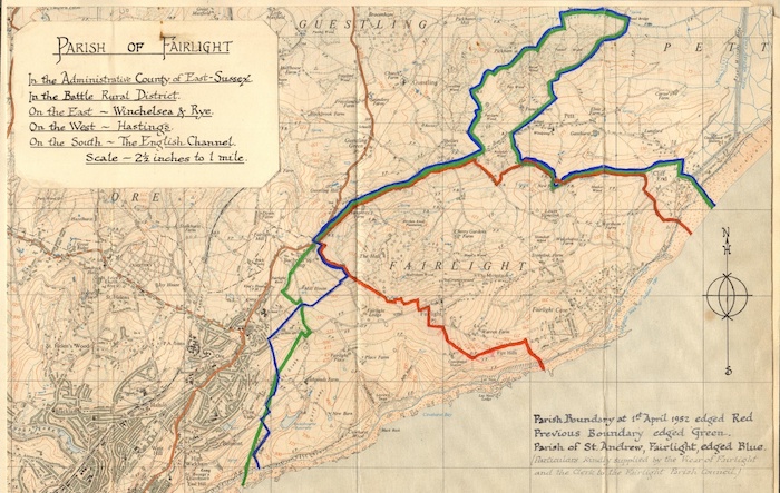
To illustrate this, we attach a map prepared by the former Fairlight WI showing the existing Parish, outlined in red as well as showing the full extent of the larger Parish, outlined in green.
The other parcels of land were transferred to Pett, Guestling and Hastings at various times .
Notable properties and areas formerly in our Parish include Fairlight Place, Fairlight Lodge, Fishponds Farm, French Court Farm, The Two Sawyers and many Pett Road houses, all the properties at Cliff End and the majority of the Hastings Country Park. Indeed many old boundary stones and marker posts can still be found if you look closely. The precise shape of the larger Parish was defined in the 1839 Tithe Map, as outlined in green.
So let us look at today’s Fairlight Parish. We attach a more recent map.

This map gives you a clear view of the territory that todays’s Fairlight Parish Council is responsible for, within Marsham Ward of Rother District Council.
But what it doesn’t do is give you any sense of the history or development or the full extent of the beautiful piece of East Sussex that we are privileged to call home.
So, just what do we mean by Fairlight? For many people Fairlight is the settlement between the Fairlight Road, Battery Hill, Pett Level Road and the sea, namely the roads branching off left and right from Waites Lane and then Shepherds Way. This is the most densely built-up area in the parish, with properties, mainly bungalows, originally dating from 1922 but with development continuing ever since. House building continues even now. This is essentially Fairlight Cove
However, for many people Fairlight is synonymous with the coast and cliffs, the Fire Hills and the Hastings Country Park – the sections of coast, with spectacular views and interesting walks, accessed from Coastguard Lane and Lower Coastguard Lane or from Channel Way. This takes in the entire coast from Cliff End at Pett Level almost as far as East Hill in Hastings.
For others, and historically, Fairlight is Fairlight Down, the fields and meadows, farms and mill on the high ground radiating outwards from North’s Seat. Just how far Fairlight Down spreads towards the sea or down into Ore is a matter for debate but that area, together with the ancient hamlet comprised of Church Farm, a small cluster of houses adjacent to the Church, and St Andrew’s Church itself, is the oldest part of Fairlight. This is where the old village school was located and also the quarries that provided the stone for the church when it was rebuilt in 1845. That Fairlight has a long history which may be adduced from the fact that the original church dated from around 1180. Much of that Fairlight is now part of Hastings, specifically the Country Park.
Archaeological evidence (flint scatters and the like) found locally strongly suggests that Fairlight has been a place of human habitation certainly since the neolithic (New Stone Age) period. But in terms of the written record we go back to the Normans. There was a Manor in Fairlight before 1066, given by William the Conqueror to the Countess of Eu (or Ow), near Caen, France – her husband was the first Constable of Hastings Castle. However, Fairlight does not feature in the Domesday Book, under this name. The land is included under Rameslie.
To learn more about our history, please speak to Fairlight History Group, whose website can be found at www.fairlighthistory.co.uk. Similarly, our archaeological story can be found under www.haarg.org.uk
